Geospatial Foundation Models
Geospatial foundation models learn one reusable overhead embedding from millions of satellite chips so new map tasks start from knowledge, not zeros.
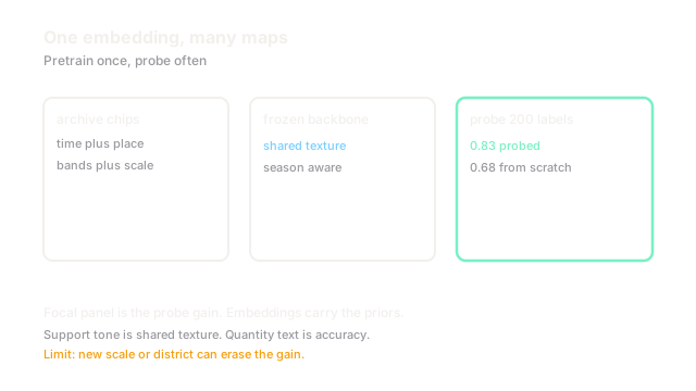
Why Does This Exist?
Labeling satellite data is slow: experts trace fields and roofs across seasons, and each new sensor restarts the work. Single task models hoard what they learn and share nothing. Archives hold millions of unlabeled chips with time, place, and bands attached.
Geospatial foundation models exist to bank that shared knowledge. Input is an overhead chip with bands, time, and location. Output is a dense embedding that later heads reuse. The setting is remote sensing; per task heads include land cover and satellite analysis.
Use them when labels are few and tasks share overhead texture. Train a specialist when you own massive labels for one sensor and one task.
Think of It Like This
A field guide author turned tutor
A field guide author who walked every county for years can teach a newcomer one valley in an afternoon, pointing at soil tone and roof lines the newcomer would miss for months.
Pretraining is those walking years across archives. The probe is that afternoon lesson for your valley. The analogy stops at place: the tutor still fails where your valley soil looks nothing like training counties, and location metadata only partly warns you.
How It Actually Works
Pretrain on unlabeled chips with masked reconstruction or contrast across time and place: hide patches and rebuild them, or pull same place views together and push far places apart. Encode bands, acquisition month, and ground sampling alongside pixels so the embedding knows season and scale. Freeze the backbone for a new task and fit a light probe: a linear layer on frozen features with labeled chips often beats a from scratch net that sees only those .
Worked example
A probe task separates wheat from barley on chips at m. From scratch training on labels reaches about accuracy and wobbles across seeds. A frozen foundation embedding plus a linear layer on the same labels reaches about because texture and season priors arrive pretrained. Adding labels narrows the gap, which shows the foundation buys most when labels are scarcest.
Watch Out For
Resolution mismatch that silently breaks transfer
A backbone trained at m learns field scale texture. Probing it at m feeds car scale edges it never saw. The symptom is confident nonsense on fine objects. Fix it by matching ground sampling or by continued pretraining on the target scale before probing.
Place leakage that inflates probe scores
Random chip splits scatter neighbor chips from one farm across train and test. The probe memorizes that farm, not wheat. The symptom is a point drop on a new district. Fix it with spatial block splits that keep whole districts apart.
The Quick Version
- Geospatial models pretrain on huge unlabeled overhead archives.
- Time, place, and bands join pixels in the learned embedding.
- Frozen features plus a light probe win most when labels number in the hundreds.
- The fixture moves from scratch to probed on labels.
- Match ground sampling and split by district or scores mislead.