Remote Sensing Vision
Remote sensing reads Earth from aircraft and satellites, turning overhead pixels with known ground sampling into maps of land, change, and activity.
Why Does This Exist?
Ground photos show facades. Governments and farms need fields, floods, and forests measured in hectares across seasons. Remote sensing exists as the umbrella for that overhead view: sensors with calibrated ground sampling distance, repeat passes for change, and bands beyond RGB. Pixels gain physical scale and time, which natural-image models ignore.
This page keeps the shared geometry and the map to children: satellite analysis, land cover, change detection, hyperspectral, SAR, aerial detection, and geospatial foundation models. Each child owns its mechanism.
Think of It Like This
A farmer with dated aerial prints
Each spring the farmer spreads new prints at known scale over last year prints and circles what changed. Scale bars make hectares honest, dates make change honest. The model does the same with GSD and timestamps. The analogy stops at paper: sensors also see infrared and radar the eye cannot.
How It Actually Works
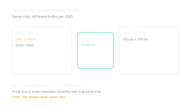
Overhead images carry ground sampling distance in meters per pixel plus acquisition time and band list. A chip at m covers km. Analyses align repeat passes by georeferencing, normalize for sun and atmosphere, then classify, detect, or difference. Resolution, revisit, and bands bound every claim: 10 m pixels cannot count cars, daily revisits catch floods, infrared separates crops.
Worked example
A field m spans pixels at 10 m GSD but at 0.5 m. Land-cover labeling works at 10 m while vehicle detection needs 0.5 m. A flood expanding water from 200 to 350 pixels at 10 m grows by 150 hectares, a number the map reports directly from times pixel count.
Watch Out For
Pixel counts without ground scale
Counting changed pixels across sensors with different GSD compares hectares to city blocks. The symptom is alarming change maps that vanish after resampling to common ground units. Convert to square meters with first, then compare.
The Quick Version
- Overhead pixels carry ground scale, time, and bands.
- GSD decides which objects are even visible.
- Revisit enables change; bands enable material separation.
- This page maps the family; children own mechanisms.
- Report areas in ground units, never raw pixels.