Visual SLAM
Visual SLAM allows a system to simultaneously map an unknown environment and track its own location within it using only camera input.
Why Does This Exist?
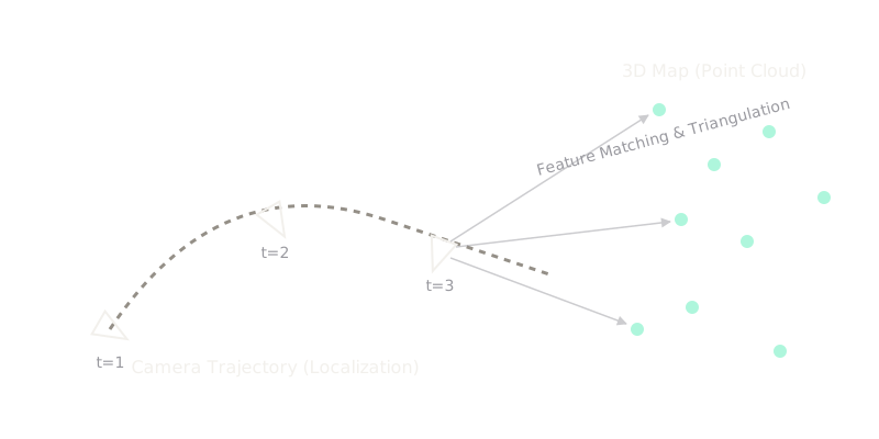
Before Visual SLAM (Simultaneous Localization and Mapping), robots and AR devices either needed pre-built maps to know their location, or external sensors like GPS and LIDAR. But GPS fails indoors, and LIDAR is expensive and bulky. Visual SLAM exists to solve the chicken-and-egg problem of navigation using just a standard camera: you need a map to know where you are, but you need to know where you are to build a map. By analyzing how pixels move across consecutive frames, a system can construct a 3D map of its environment while simultaneously tracking its exact pose (position and orientation) within that map.
Think of It Like This
Imagine waking up in a completely dark, unfamiliar room with a flashlight. To figure out the room's layout (mapping) and your position in it (localization), you shine the light on a distinct object, like a chair. As you take a step, the chair appears to shift in your vision. By estimating how much you moved and how the chair's apparent position changed, you can guess both where the chair is and where you stepped. Do this continuously for hundreds of points in the room, and you eventually build a mental map of the space while knowing your exact location within it.
How It Actually Works
Visual SLAM typically operates in a pipeline with three major components running concurrently:
- Feature Extraction and Matching: The system takes a camera frame and detects distinct visual features (like corners or edges). When the next frame arrives, it finds these same features. By tracking how these points moved (visual odometry), it estimates the camera's motion between the two frames.
- Local Mapping and Bundle Adjustment: As the camera moves, the system triangulates the 3D positions of the matched 2D features to build a point cloud. It continuously runs an optimization process called Bundle Adjustment, which refines both the estimated 3D map points and the camera's trajectory to minimize reprojection errors (the difference between where a point should appear in the image and where it actually was detected).
- Loop Closure: If the camera returns to a place it has seen before, it recognizes the familiar features and "closes the loop." This is crucial because small errors in camera tracking accumulate over time (drift). Recognizing a previously mapped area allows the system to snap the entire map and trajectory back into global alignment, correcting the accumulated drift.
Watch Out For
Featureless or Dynamic Environments
Visual SLAM relies heavily on tracking stationary, distinct features. If the camera looks at a blank white wall, a highly reflective mirror, or a crowd of moving people, the system will fail to extract reliable points. When tracking fails, the entire localization and mapping process breaks down.
The Quick Version
- Simultaneous: Solves mapping and localization at the exact same time.
- Odometry: Uses tracked features between frames to estimate the camera's relative motion.
- Optimization: Continuously refines the 3D map and camera poses to minimize mathematical errors.
- Loop Closure: Corrects long-term drift when the system recognizes a previously visited location.