SAR Imagery
SAR is radar vision that sees through clouds and darkness by sending its own signal and reading the echo, trading pretty pictures for all weather sight.
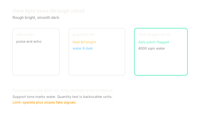
Why Does This Exist?
Optical satellites go blind under monsoon cloud and at night, exactly when floods peak and ships move. Relief teams cannot wait for clear skies. Radar carries its own illumination: it shouts in microwaves and listens for the echo, day or night, through cloud.
SAR imagery exists to read that echo. Input is complex radar returns sampled along flight and range. Output is backscatter strength plus phase per ground cell. The overhead umbrella is remote sensing; optical per date analysis is satellite imagery. Band based material work is multispectral imaging.
Use it when cloud, smoke, or night blocks optics. Use optics when color and fine texture decide the class.
Think of It Like This
Shouting in a dark gym to map it
You clap in a dark gym and listen. Curtains swallow sound and return almost nothing. Bleachers scatter it back loudly. A new mat on the floor changes one echo patch from loud to quiet.
SAR claps with microwaves. Smooth water is the curtain, rough fields are bleachers, flood is the new mat. The analogy stops at wavelength: radar echoes also carry phase that sound mapping ignores, and that phase measures millimeter shifts.
How It Actually Works
A side looking antenna synthesizes a long aperture from flight motion, giving fine azimuth resolution from a small dish. Each cell records backscatter : smooth surfaces reflect away and look dark, rough surfaces scatter back and look bright, corner shapes like buildings blaze. Speckle from coherent interference grains every image, so multilook averaging trades resolution for cleaner tones. Repeat pass phase differences flag millimeter ground motion and fresh water.
Worked example
A field reads backscatter units rough and dry. Floodwater smooths it to units, a drop of units. Speckle jitters stable cells by about units after multilooking. A threshold at units keeps stable field at and flags water at . A cell patch below threshold at m sampling covers square meters of new water.
Watch Out For
Speckle mistaken for texture
Raw SAR grains with bright and dark dots that look like trees or houses. The symptom is classifiers that ace training tiles and collapse one field over. Fix it with multilook or adaptive speckle filtering before features, and never train on single look amplitudes alone.
Geometry read as ground truth
Slopes facing the sensor compress and brighten while far slopes stretch dark, and tall buildings lean toward the sensor. The symptom is flood maps that follow ridges. Fix it with terrain correction using elevation data and by masking layover zones before measuring area.
The Quick Version
- SAR sends microwaves and reads echoes through cloud and night.
- Backscatter is dark on smooth water and bright on rough ground.
- The fixture flags unit water against unit field at a unit cut.
- Multilook filtering tames speckle before any model sees the image.
- Terrain correction comes before area math in hills and cities.