Agriculture Vision
Vision models scan fields from drones and tractors to spot disease, weeds, and ripe crops early, so growers spray less and harvest on time.
Why Does This Exist?
A wheat grower with 400 hectares cannot walk every row. By the time yellow rust is visible from the road, it has taken 20 percent of the plot. Blanket spraying the whole field costs money and harms soil. Agriculture vision exists to turn overhead images into actions: which patches are diseased, where weeds cluster, which rows are ready.
The job splits from neighbours. Image classification says diseased or healthy for one leaf photo. Object detection finds each plant. This page is the field system: flight, stitching, detection, and a spray map with a measured false alarm rate.
Basics first: a detector outputs a box plus a score between 0 and 1. Scores above a threshold fire an alert. Lower the threshold and you catch more disease but spray more healthy plants. The full treatment of that tradeoff is in mean average precision.
Think of It Like This
A crop scout with a highlighter map
A scout walks rows with a clipboard, marks sick plants with a yellow highlighter, and hands the tractor driver a map that says spray only the yellow blocks. The driver skips the rest. Drone vision is that scout flown at 60 meters: the camera is the eyes, the detector is the highlighter, and the spray map is the handoff. The analogy stops at judgment: the scout knows last weeks rain, while the model only knows pixels and needs that context as inputs.
How It Actually Works
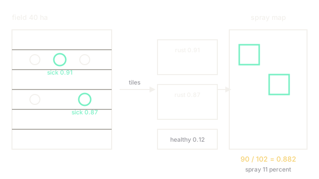
Flights capture overlapping RGB frames at 2 to 3 cm per pixel. Software stitches them into one orthomosaic, corrects for sun and shadow, then tiles it into 512 by 512 patches. A detector scores each tile for rust, mildew, and weeds. Scores above 0.5 become boxes. Boxes merge across tile edges. The merged boxes paint a spray map at 5 meter cells: spray a cell if it holds at least two confident boxes.
Lighting and growth stage are the assumptions. Train on noon sun and test at dusk and scores drop. Train on seedlings and test on heading wheat and leaves look different. Keep flight height, camera, and growth stage matched between train and deploy, or recalibrate.
Worked alert count
One 40 hectare flight yields 1,800 tiles. The model fires 102 spray alerts. Agronomists confirm 90 true diseased patches, 12 false alarms on nutrient stress, and miss 18 diseased patches seen on foot. Precision is 90 divided by 102 which equals 0.882. Recall is 90 divided by 108 which equals 0.833. Spraying only alerted cells treats 11 percent of the field instead of 100 percent.
Watch Out For
Weed models that memorize one soil color
Training on one dark soil farm clusters every green blob correctly there and fails on sandy soil where background is pale. The symptom is perfect home field scores with near zero recall two farms over. Fix it by mixing soils and lighting in training and by testing on a held out farm, not a held out row.
The Quick Version
- Agriculture vision turns drone mosaics into spray maps, not just leaf labels.
- Tiles score disease and weeds, boxes merge, cells spray on two confident hits.
- Our flight fired 102 alerts with 90 true, precision 0.882 and recall 0.833.
- Match camera height, light, and growth stage between train and deploy.
- Test on a new farm to catch soil color overfitting.